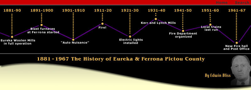
History of Eureka & Ferrona
Eureka is a unique and picturesque village, completely surrounded by
hills and bestowed by a benign nature with a natural observation
balcony, where the scenes and activities below can be clearly viewed
from many angles. Seen form the sloping hills on the eastern or
western approaches, the village presents a quiet and peaceful
appearance in the widespread panorama of the surrounding
countryside, dotted here and there and on the opposite hills with
homes and buildings, a contrast and blending of the various shades
of green, in the foliage, the fields and the gardens, here and there
occasional sparklings of the river, and in the Autumn, the leaves
and verdure, changing and bursting out with all their glorious and
vivid colors, presenting beauty at its best. Keeping silent watch
over the tranquil scene and the destiny of this little village,
along the river banks and high on the hills, are a few remaining,
tall and stately trees, patiently recording the change of seasons
and seeing the tide of events in the community, as they have done
since before its creation. Also keeping a benevolent watch from
almost the center of the village, erected early in its history, and
– gleaming white – is stately Zion Presbyterian Church, with its
tall, imposing spire and commanding appearance.
If we could turn back the pages of time to 1877, ninety years ago,
stand on the high road and view the scene as it was displayed at
that time, what would be seen? In the village proper, probably,
nothing but wilderness, the two or three small clearings invisible
among the trees. On the opposite hills of Churchville, there could
possible be seen buildings and growing clearings and there might
also be seen an occasional domestic animal. The branches of the East
River, teeming with fish, at that time, could not be seen, because
of the high banks and surrounding forest, which also abounded with
game and other wild animals. Quite a strip of the Intercolonial
Railway should be visible and it is quite likely that you would be
treated by the appearance of a train as it chugged its way along.
Coming from Stellarton and extending up to the East River
Settlements would be a roadway, this could likely be seen as it
crossed the railroad, but the bridge across the West Branch of the
East River could not be seen, this was then known as the Island
Bridge and was the only name applied to the area, although a few
years later it was spoken of as Lower Hopewell for a short time.
The earliest drawing of surveyor’s map, show the location of the
various grants of land made to the pioneer settlers. That of
Farquhar Falconer, extending to the West Branch of the East River,
would include the southern portion of the future village, while the
grant of Alexander Falconer, would include the remainder west of the
West Branch. The portion now known as the Island and bounding the
village of Ferrona on the south was Granted to Alexander MacKay;
James Robertson and Charles Fraser had the Churchville land, east of
the East Branch of the East River. The portion now occupied by the
village of Ferrona was not taken up at that time. It was,
subsequently, taken up by later grants to Farquhar and Alexander
Falconer, and others, who were accorded grants in 1813, 1814, and
1820. As the East River settlements grew and developed, a roadway
was opened up from there to the more populated areas, or towns as we
know them today. Coming from Stellarton, the roadway followed down
the big hill, then known as Barclay’s Hill, following the same
course of the road, as at the present, to the bend of the smaller
hill leading to the bridge, here it inclined to the right and passed
along the route, now followed by Mr. James Jardine to his garage, it
continued around the hill to where the Island Bridge had been built,
crossing the bridge to the other side, the old road can still easily
be followed up to the property of Mr. Fraser MacDonald, from there
it continued to the Island, along the foot of the small hill about
150 yards west of the present highway and eventually converging with
it.
1881-1900

|