| |
Back Shore |
| |
The area on the north shore of Cape John was named the "Back Shore"
because of it's geographic location in relation to the village of River
John. The first landowners were Philip Marchinton, about 1811, and the
Halifax businessman James Lidell in 1821. Neither Marchinton or Lidell
lived on their Pictou County properties. Lidell was given the land to compensate
him for land in Halifax County taken over for (Negro) settlement. |
| |
| |
Cape John |
| |
 The long point of land
jutting into the Northumberland Strait is the River John's estuary, and
Bay John's eastern land boundary. To mariners the Cape is Pictou County's
western boundary. Natives of the Isle of Lewis were the pioneers: (3) MacLeods;
William, Allen and Alexander, and John Morrison, John MacIver, and Donald
MacFarlane, likely in 1808. It is thought that John Williamson settled
at Williamson's Brook in the district in 1811. The long point of land
jutting into the Northumberland Strait is the River John's estuary, and
Bay John's eastern land boundary. To mariners the Cape is Pictou County's
western boundary. Natives of the Isle of Lewis were the pioneers: (3) MacLeods;
William, Allen and Alexander, and John Morrison, John MacIver, and Donald
MacFarlane, likely in 1808. It is thought that John Williamson settled
at Williamson's Brook in the district in 1811. |
| |
| |
Diamond |
| |
Likely the farmers who chose this name considered their district a
gem. Located on the headwaters of the West Branch of River John, this rural
settlement was named in 1892, when a post office was opened there. The
district was settled as early as 1806 by John Nevin, a Scot, who came from
Renfrewshire in 1812. He was given a grant two years later. Land was granted
to Alexander Mackay in 1867. |
| |
| |
Hodson |
| |
A Johnson family came to this place four miles from River John, around
1808. An early settler may be responsible for naming the area, but it is
not known for sure. |
| |
| |
Loganville |
| |
This settlement near the headwaters of the West Branch of River John
was probably named after J. Logan who had a tannery there in the late 1780's.
Early grantees were Malcolm MacDonald in 1814, Andrew Munro in 1815, and
John Murray in 1817. John Rogers was given land in 1813, which accounts
for the name of Roger's Hill. |
| |
| |
Louisville |
| |
Situated on the back road from River John to Tatamagouche near the
Colchester County border, it may have been named after settlers Louis Langille
and Lewis Tattrie, or after the Isle of Lewis from when pioneers Hugh Munro
and Alexander Smith resided there. |
| |
| |
Marshville |
| |
Located on the south side of River John estuary. It was settled around
1792 by four Langille brothers, sons of David Langille. Numerous Truro
residents have cottages there. |
| |
| |
Mountain Road |
| |
This rural area is about four miles south of John's Bay near the Colchester
boundary. Grantees in 1811 were James Mathew, Joseph, James, and George
Frederick Langille. |
| |
| |
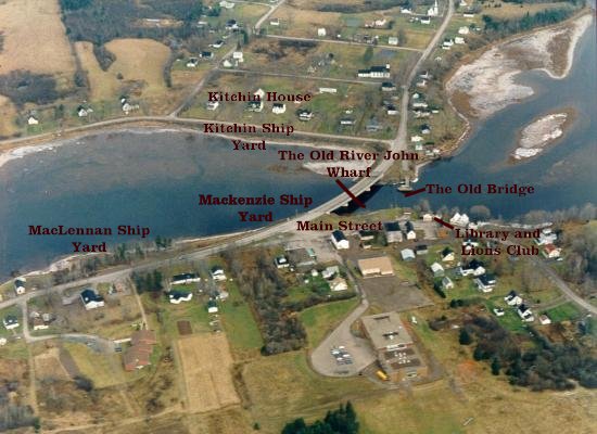
River John |
| |
First known to the Indians as "Kajeboogwek",meaning "flowing through
a solitary place". The stream was once called "Deception River". The name
River John may have come from "Riviere Jaun". In the maps of the 1770's
it was called "River John". |
| |
| |
Seafoam |
| |
Located on the east side of Cape John, when the wind blows and the
tide rises, the seas till in and pile up in foam. The early arrivals in
the beginning of the 1800's were Norman MacLeod, Donald MacKenzie, John
MacIvor, Allan MacLeod, Donald MacCully, and Donald Gillis. |
| |
| |
Toney River |
| |
A French explorer, Captain Toney, joined the Indians and became a Mi'maq
chief. The river was knwon to the Indians as "Booktowoogen", which means
"the place for fire or flint". James Milne in 1808 had a sawmill and was
shipping timber from Toney River to England in 1810. Early settlers were
George MacIvor, Albert Munroand Norman MacLeod. |
| |
| |
Welsford |
| |
A British army hero who died in the Crimean War, Major Augustus Welsford,
gave his name to this Pictou County place near River John in 1858. D. Langille
had a grist mill here in 1806, and Robert Sutherland, a tannery in 1878. |
| |
| |
Westerly |
| |
This name perhaps was chosen because of the vulnerability to west wind
blowing across John's Bay. John Joudrie and Patrick Murphy were grantees
in 1815 and Mary Hayden in 1717. |